Skip to Content
Community Geography Collaboratory

Community Geography Collaboratory

A hub for community-driven maps & spatial data in Northeast Ohio

  • Home
  • Data: Environmental
  • Data: Social
  • Data: Economic
  • Data by Location
  • Visit us in McGilvrey Hall
Home Maps Environment Bioblitz observations
Updated on 2023-08-172023-08-17Environment Maps

Bioblitz observations

Jennifer Mapes

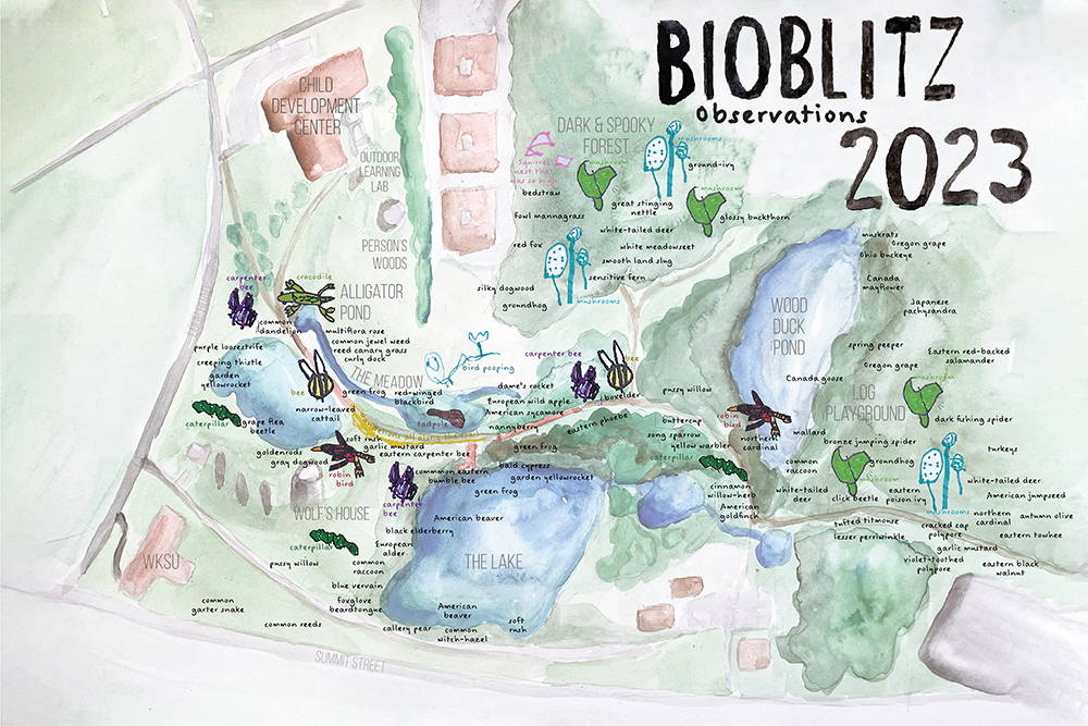
Community Geography includes campus research and education activities. In April 2023, we worked with folks from across campus to host the Bioblitz. Here’s what we saw, including drawings from children at the Childhood Development Center.

Previous Article Around the Block: A walk-a-day COVID map
Next Article Safe Routes to School
Map showing sidewalks and crosswalks in 1 mile radius to Walls Elementary School.

Recommended Articles

Updated on 2025-09-112025-09-11Maps People & Culture

Mapping local elections

A map of Ohio 2020 election at the precinct scale with one dot representing each vote and colors by precinct based on voting outcome, illustrating classic urban/rural divide but also a slightly less Republican lean in small towns.
Updated on 2023-08-172023-08-17Economic Maps

Downtown Kent wayfinding map

Updated on 2024-02-182024-02-17Maps People & Culture

Safe Routes to School

Map showing sidewalks and crosswalks in 1 mile radius to Walls Elementary School.

Data for Northeast Ohio

  • Data by Location
  • Data: Economic
  • Data: Environmental
  • Data: Social
  • Supporting GIS in local government

Map news

  • Mapping local elections
  • Who lived here? Mapping Kent’s South End
  • Urban renewal in Warren, Ohio
  • Safe Routes to School
  • Bioblitz observations
© Copyright 2025 Community Geography Collaboratory. All Rights Reserved. Yummy Recipe | Developed By Blossom Themes. Powered by WordPress.